Institute for Earth Observation - Advanced Computing
Advanced Computing
- Deutsch
- English
- Italiano
In an era of ever-growing earth observation (EO) data this group has the main objective to research and implement innovative solutions for simply accessing and processing EO data. Our group helps researchers monitoring and understanding of environmental processes, by enabling them to fully capitalize on the potential of the available data, in the temporal, spatial and feature domain. The group further fosters EO data science by actively contributing to research and development in regional and international projects.


© Eurac Research
Big Earth Observation Data Science
This research line focuses on the scientific questions in the domain of computing technologies and software development for effective and efficient handling of EO data at scale. This includes research on the design and implementation of data cubes, on the fly processing, harmonization of access to heterogeneous data, integration of machine learning techniques and computing in cloud distributed environments.

© No copyright
Scientific Data Management and Processing
This topic brings science into action by bridging the gap between researchers, data and their processing needs, in a demanding big data environment. At the Institute level, we are hosting and processing the full MODIS and ESA Sentinel Satellite data time series for the Alpine arc as well as data from many other EO satellites and sensors. To create an efficient environment for research, the group is operating both on a private infrastructure of scalable petabyte storage and high-performance computing and on public cloud service platforms. Encouraging the uptake of novel technology in a constant dialog with the researchers, the data and development cycles are adjusted to inform real-world problem solutions and related research questions.

© stock.adobe.com
Publications
The scientific publications of this research group are the following:
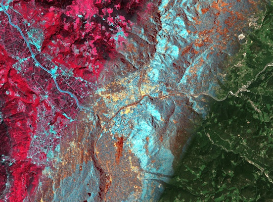
The evolution of snow state in Venosta Valley (BZ) throughout the years 2015 and 2016. The algorithm to retrieve snow state from a fusion of Sentinel-1 radar and optical MODIS imagery is implemented on Euracs openEO cloud infrastructure. © Eurac Research | Institute for Earth Observation, groups Advanced Computing for Earth Observation and Earth Observation for Environmental Monitoring
This video shows a sequence of True Color imagery from January to October 2016 over South Tyrol. The cycle of the season can be seen from the growing vegetation in the valleys and the snow cover changes on the mountains tops. Credit: Contains modified Copernicus Sentinel data [2016]/ESA
This video shows an animation of the Sentinel-1 Interferometric Coherence over South Tyrol in 2017, used to generate a land cover classification © Eurac Research | Michele Claus