Institute for Earth Observation - Biosphere and hydrosphere
Biosphere and hydrosphere
- Deutsch
- English
- Italiano
The Biosphere and Hydrosphere research group uses Earth Observation to investigate the spatial-temporal dynamics of the terrestrial water cycle, vegetation conditions, and land cover with a specific focus on the Alps. We develop innovative tailored methods for processing optical, thermal, and radar imagery addressing the heterogeneity and topographic complexity of mountainous regions. The products and information that we derive mainly from satellite data are used for different hydrological, agricultural, and ecological applications.
Terrestrial water cycle
Through Earth Observation we aim to improve the monitoring, modeling, and understanding of the water cycle in mountainous regions. Based on optical, thermal, and radar satellite imagery, we develop products such as soil moisture and evaporation that are used in combination with process-based and data-driven hydrological models. In addition, we generate drought indices that contribute to drought risk management from the local to the Alpine scales.
Vegetation and land-use dynamics
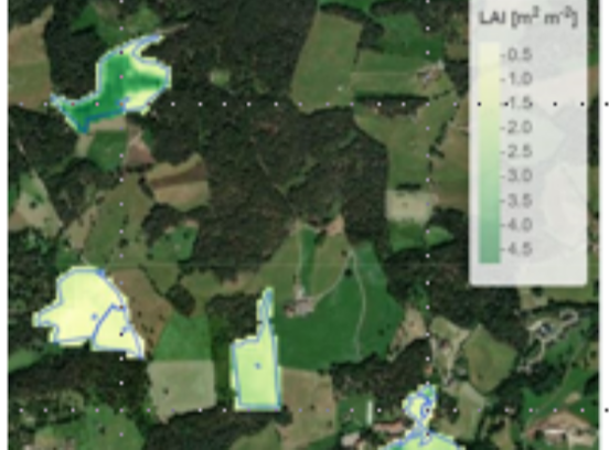
Our research aims to monitor and understand the spatial-temporal dynamics of highly variable mountain vegetation, specifically focusing on mountain forests and grasslands that dominate the alpine environment. We use optical and radar satellite data in combination with in-situ data to monitor land-cover dynamics as well as bio-physical vegetation parameters at different scales, and to understand the impacts of climate and land use changes.


© stock.adobe.com
Publications
The scientific publications of this research group are the following: