ScaleAgData
SCALING ΑGRICULTURAL SENSOR DATA for an improved monitoring of agri-environmental conditions
- Deutsch
- English
- Italiano

- Project duration: -
- Project status: ongoing
- Institutes: Institute for Earth Observation, Center for Sensing Solutions
Project funded by

ScaleAgData is a four-year project funded by the EU program Horizon Europe. Eurac Research is one of the 26 partners of the consortium led by VITO (Belgium). The vision of ScaleAgData is to obtain insights in how the complex data streams should be governed and organized, as well as to develop the data technology (from data streaming, data analytics and artificial intelligence (AI) applications) needed to scale data collected at the farm level to regional datasets built for agri-environmental monitoring and the management of agricultural production. This will be achieved through a number of well-chosen Research and Innovation Labs (RI Labs), where different data upscaling and integration models or approaches will be evaluated and demonstrated. Recommendations will be formulated on how such integrated datasets can be capitalized to help national and regional policy making to strengthen both the competitiveness and sustainability of European agriculture. The main role of Eurac is to develop innovative methods to improve the estimation of grassland ecosystems biophysical parameters and biomass, applying these methods within the grasslands RI Lab. The main objectives of Eurac are a) consolidating our methods to estimate the productivity of mountain grasslands by satellite data, b) develop new techniques to exploit synergies between different satellite-based sensor, c) monitoring and understanding the impacts of climate change and climate extremes on Alpine ecosystems. Contact: Mariapina Castelli mariapina.castelli@eurac.edu |


Castelli M, Peratoner G, Pasolli L, Molisse G, Dovas A, Sicher G, Crespi A, Rossi M, Alasawedah MH, Soini E, Monsorno R, Notarnicola C (2023)
MDPI AG
Journal article
Remote Sensing
More information: http://dx.doi.org/10.3390/rs15143542
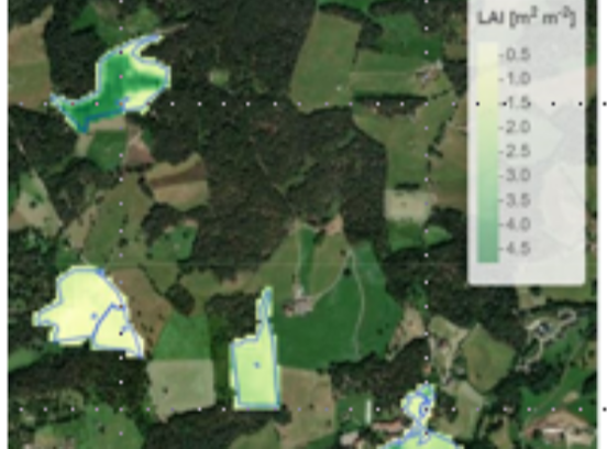
Spatial Gap-filling
Göhner C, Alasawedah MH, Mejia-Aguilar A, Peratoner G, Dovas A, Sicher G, Stendardi L, Bartkowiak P, Claus M, Cuozzo G, Castelli M (2023)
Presentation/Speech
Conference: 8th International Workshop on Retrieval of Bio- & Geo-physical Parameters from SAR Data for Land Applications | Rome | 15.11.2023 - 17.11.2023
More information: https://scaleagdata.eu/en/presenting-biogeosar-2023-rome
Castelli M (2022)
Newspaper
CodipraNews: Periodico del Consorzio Difesa Produttori Agricoli Co.Di.Pr.A.
More information: https://www.codipratn.it/wp-content/uploads/2022/12/Numero_4 ...


Mohammad Hussein Alasawedah
Team Member


Basil Tufail
Team Member