Tools & ServicesInstitute for Renewable Energy
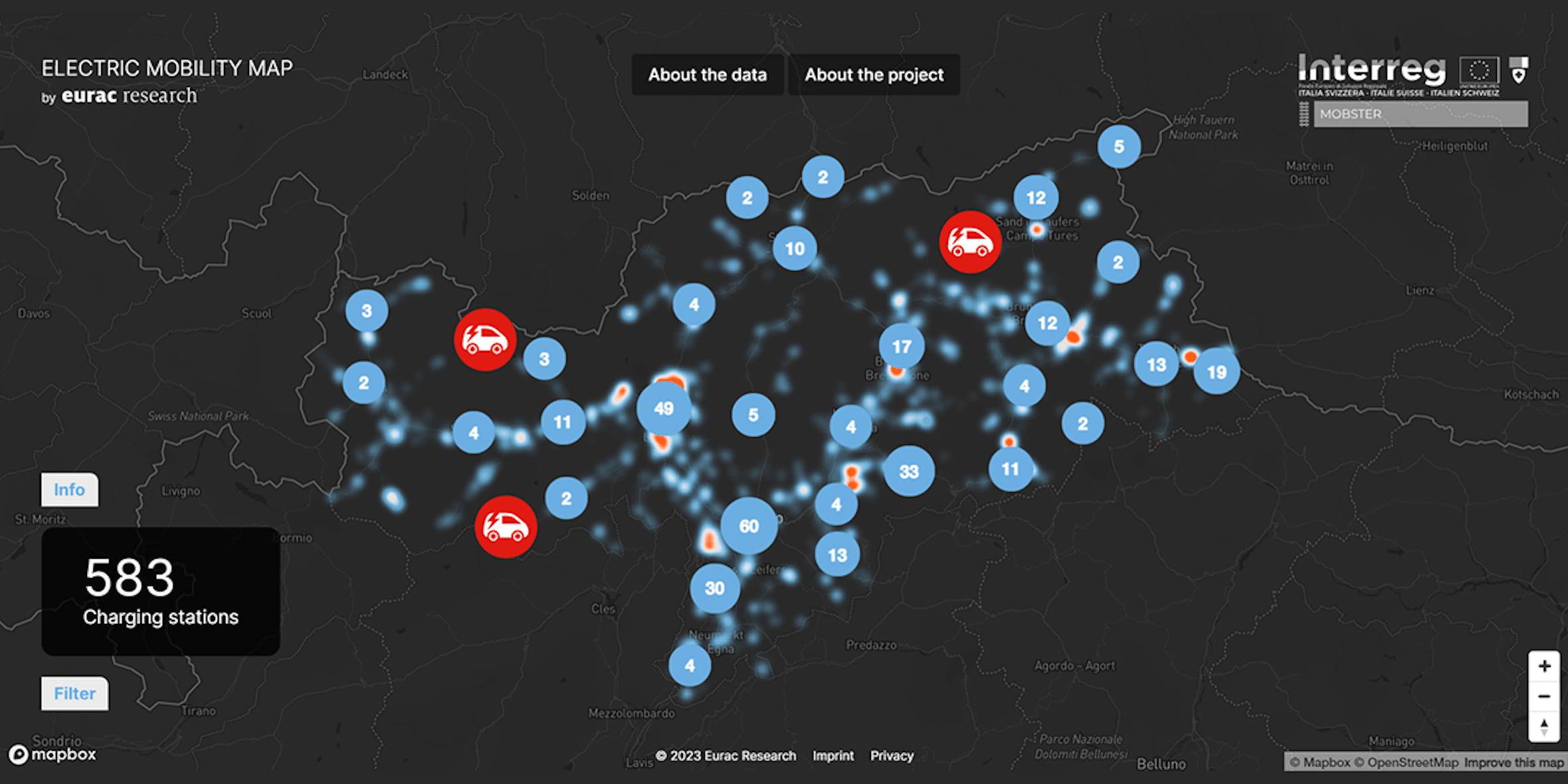
# GIS energy mapsPositioning of charging infrastructures in cities and regions
Since several years Eurac Research has been working on identifying the most suitable spots for positioning of charging station based on traffic flows and various points of interest applying multilayer GIS maps. Recent examples are the activities executed within the project Mobster or evaluations carried out in cooperation with the Joint Research Centre (JRC)
- English
The Atlas of e-mobility infrastructure needs
The Atlas of infrastructure needs for electric mobility has been developed within the Interreg IT-CH MOBSTER project. In the project, the analysis was applied in 3 case studies (Alto Adige, Verbano Cusio Ossola, Canton Ticino) but the methodology is transferable to other contexts and adaptable to other types of users.
The maps are the result of the electric mobility infrastructure needs analysis in 3 different areas: South Tyrol, Verbano-Cusio-Ossola and Canton Ticino. The method was designed in a GIS environment, using an algorithm that overlay different layers. In this case, the calculation process consists of a weighted sum of so-called "points of interest" (POIs), i.e. those places which, for a certain reason, generate a form of attractiveness to tourists. Specifically, three categories of POIs were considered:
- tourist poles (such as natural parks);
- existing infrastructures (such as railway stations);
- mixed activities (such as hospitals).
The results of this analysis are maps representing on a scale of values the most and least suitable areas for the installation of new charging points for the considered users
The maps are consultable at this link. For a correct and useful interpretation of this web atlas please refer to the contacts at the bottom of the page
Electric cars: a map to support sustainable mobility
Back in 2016, Eurac Research conducted a study analysing the city of Bolzano and South Tyrol to find out where best to position electric car charging stations.
In order to best position charging stations, several factors must be taken into account: The population density, but also the location of the electricity grid and the largest car parks where it would be easiest to install new charging points. Other factors to be taken into account are the presence of existing stations and highly populated businesses: shopping centres, areas with restaurants and entertainment, public places such as museums and universities.
All this information converges in a single map of the city divided into three colours according to the scores received. Within the areas with the highest scores, local administrators can decide where to place new charging stations.
The study also analysed the provincial level and created a map of where to place the recharging stations along suburban roads and motorway stretches. In doing so, it took into account the existing infrastructure where charging points could be placed and a maximum distance of 60 km (for motorways) and 30 km (for country roads) between charging points.
Here below the pdf of the study
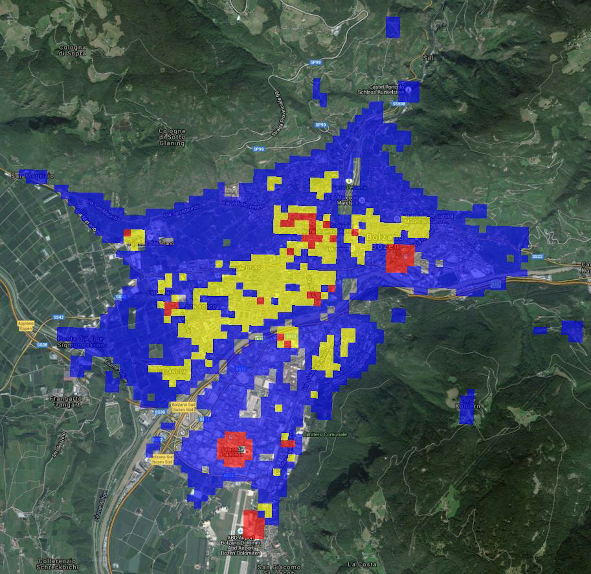 Photo: Grainne Mulhern | All rights reserved

2021EnerMaps open data tool
The EnerMaps Open Data Management Tool aims to improve data management and accessibility in the field of energy research ...

2020HotMaps
GIS-based online software that supports authorities and energy planners to set up a strategic heating and cooling plan ...

2020Positioning of charging infrastructures in cities and regions
Since several years Eurac Research has been working on identifying the most suitable spots for positioning of charging ...

2018Greta Simulation Tool
Economic and financial simulation tool for the evaluation of the Near Surface Geothermal Energy (NSGE) systems potential ...

2016GRASS ADD-ON r.green
The software is an add-on of the GRASS software which computes the residual energy potential of different renewable ...

2014Solar Tirol - Solar Potential Database
Geo-referenced solar potential data base, which allows private users and public bodies to estimate the solar potential ...