Increasingly, cosmic ray probes are being used to monitor soil moisture and estimate the amount of water available in the form of snow in the mountains. A joint research project with the University of Innsbruck combines the advantages of this technology with those of satellite images. So, how do cosmic ray probes work? What are their advantages? And, what needs to be considered when using them in the mountains?
What are cosmic rays?
A brief physics review: cosmic rays are particles of energy that arrive from space, “pierce” the atmosphere and strike the Earth. German physicist Victor Hess won a Nobel Prize in 1936 for discovering cosmic rays after having spent decades seeking an explanation for these strange radiations he had been observing in the environment.
On their journey downward, cosmic rays interact with whatever they encounter and produce high-energy neutrons that hit the ground before rebounding into the atmosphere. Neutrons that collide with hydrogen atoms on the ground come back weaker, with significantly less energy than they had on the first part of their journey.


At some point, a light bulb went on in someone’s brain: hydrogen atoms on the ground are mainly found in water so, what if we measured the “returning” neutrons to derive information about the presence of water in the soil? The wetter the soil, the less energy would return to Space....
Cosmic rays to measure soil moisture and regulate irrigation
Cosmic Ray Neutron Sensors (CRNS) have already been used in science since more than a decade; however, their use is expanding. Meanwhile, also the FAO is advocating their use to optimize irrigation and save water because they are an excellent compromise ̶ compared to point measurements on the ground they give information on larger surface areas and are more precise than satellite images.
The FAO is advocating the use of cosmic rays to optimize irrigation and save water.
Cosmic rays in the mountains
In mountain areas, probes that measure cosmic ray neutron sensors (CRNS) have an additional advantage: “There are places, especially at high altitudes, where it is difficult if not impossible to access to set up a measuring station using other technologies. With a range of around 200-250m, cosmic ray probes are a great solution,” explains Paul Schattan, geographer at the University of Innsbruck. As part of the ACR-Water project, Schattan and a team from Eurac Research combined cosmic ray technology with satellite imagery to measure a piece of data that is as important as it is difficult to obtain: the water equivalent of snow ̶ how much water is available in the form of snow.
Where satellite images do not suffice, cosmic rays can help. Schattan wrote the lines of code that are used to derive data on the neutrons “bounced back” from hydrogen molecules to ascertain the amount of snow on the ground and, consequently, the amount of water that will melt and slide downhill the following spring. “Thanks to information from the probes installed in Tyrol, we have already been able to improve the model that predicts flooding of the Inn River. In August 2023, we also directly derived estimates of the soil saturation to support the flood forecasting.,” he explains.
For the ACR-Water project, data from the same probes was combined with data collected from the Eurac Research probe in Corvara, Val Badia.

High-resolution satellite images have proven to be indispensable in completing the picture and providing support for a hydrological model of the region.
The Eurac Research team then processed, or in the technical jargon of remote sensing, conducted “image classification” of the satellite images to create increasingly accurate maps.
“Starting with data from the Sentinel 2 satellite , we developed an algorithm that would classify the image by providing a snow cover fraction map. This kind of map shows the percentage of an area covered by snow for each pixel in the image,” explain the Eurac Research representatives Ludovica De Gregorio and Giovanni Cuozzo. “The algorithm we used is based on artificial intelligence techniques, and by ‘training’ the model we improved upon Copernicus’s snow cover fraction estimate ̶ the reference map made by the European Union's Earth observation program.”
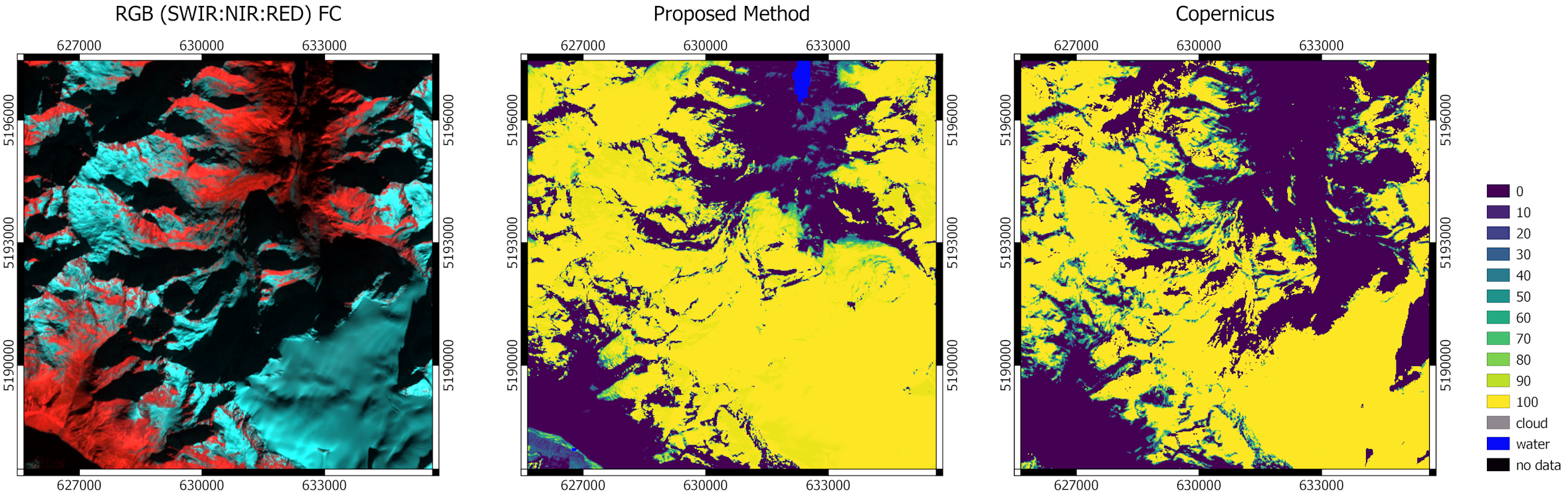 Photo: Copernicus Sentinel data 2020, processed by Eurac Research apart from the image on the right processed and provided by Copernicus Land Monitoring Service
Left: the original image sent by Sentinel 2. This is an optical image, albeit with distorted colors, of the Tyrol and South Tyrol area. An optical image means that it was captured by optical sensors, with a technology similar to that of cameras although obviously more sophisticated. The other big family of satellites that are used to capture images are radar sensors. Centre: the image processed by the Eurac Research team. In yellow the values of snow cover fraction ̶ the areas covered by snow. Right: The map developed by the European Union’s Copernicus Earth observation program, taken as a reference. The comparison shows how the Copernicus product underestimates the shaded areas – the darker parts of the first image and reports them as snow-free. The algorithm developed by Eurac Research was able to detect the presence of snow even in shaded areas.
Very high-resolution images, detailing objects up to two meters apart, were then used to check the validity of the generated map and were also processed and used as a comparison for assessing the actual snow cover. The ultra-high-resolution images are from the WorldView satellite.
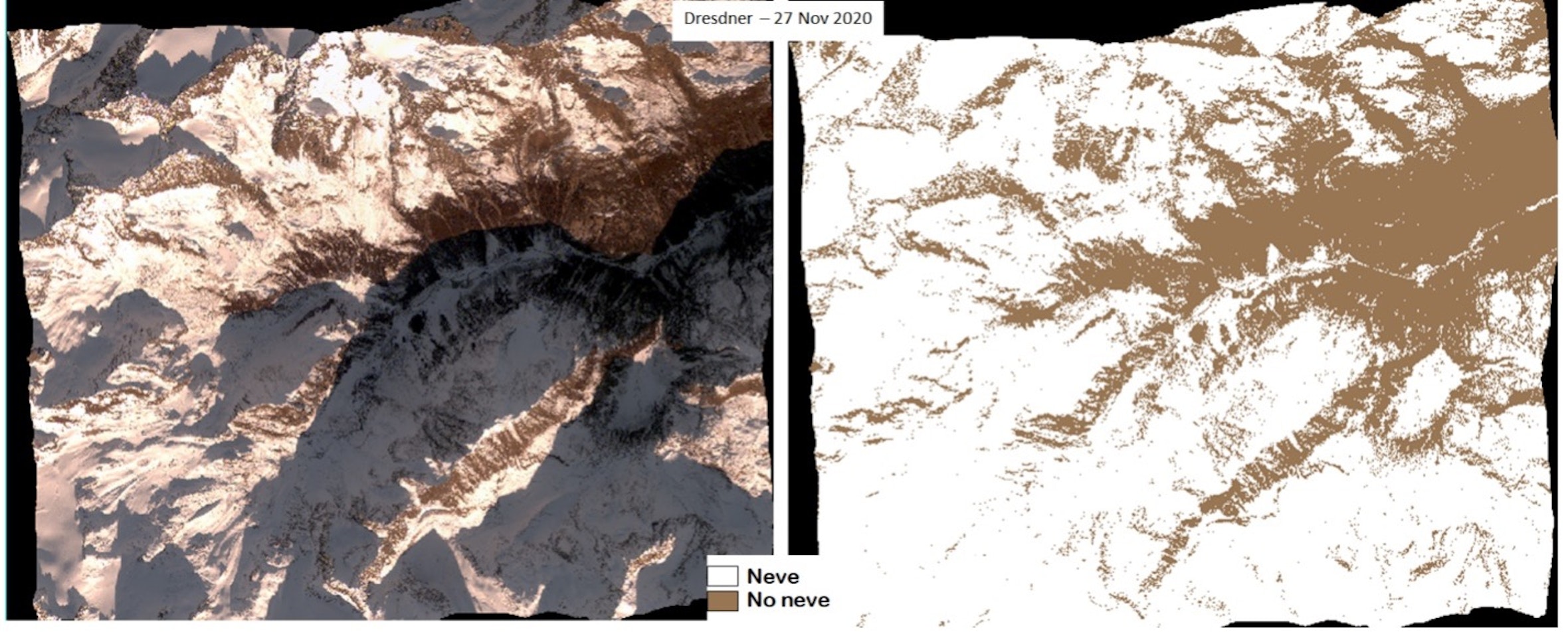 Photo: DigitalGlobe, Inc. (2020), provided by European Space Imaging | All rights reserved
High-resolution satellite image, with classified version on the right. The image was acquired on November 27, 2020 in the test area around the Dresdner Hut near the Stubai Glacier in Tyrol.
The research team used additional satellite images as an aid for estimating the extent of moisture on the ground, in particular they chose Sentinel-1 microwave and Landsat-8 optical images which had also been classified with artificial intelligence-based algorithms.
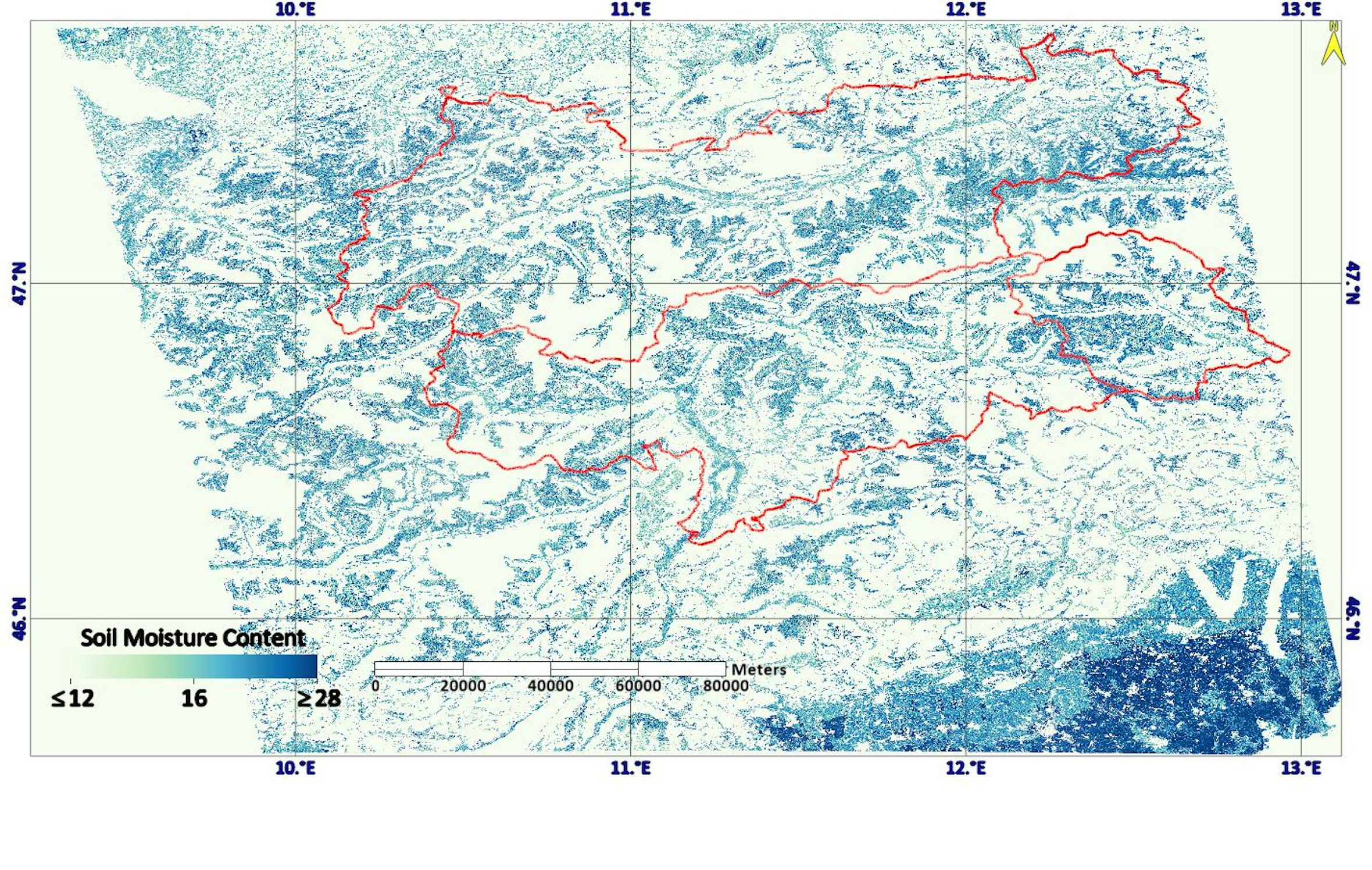 Photo: Image obtained processing data available on Google Earth Engine | All rights reserved
Map of soil moisture on September 18, 2021. The color blue shows soil moisture. Red lines mark North Tyrol, South Tyrol, and East Tyrol. It can be seen that in the westernmost valleys and Lower Adige, except for the Isarco/Eisack river line, light shades of blue which correspond to drier areas, predominate.
“The research world and even government departments are increasingly investing in these hybrid forms of monitoring and on cosmic ray probes to better monitor the natural resources of the land,” De Gregorio and Cuozzo explain. “In addition, our maps, due to their ability to display high-resolution topographic features of the terrain will also be useful in choosing the ideal locations to place sensors.”