


Planning the landscape from an ecological perspective
In conversation with an ecologist and a spatial planner on the topic of ecological connectivity
Last June, Eurac Research hosted the 14th Italian Congress of Theriology, the annual event that brings together mammal researchers. As it does every year, the congress served as fertile ground for fostering connections between people and fields of study. This was exactly the case for Peter Laner and Luca Börger, who spoke precisely about connections: green ones.
What do you do?
Peter Laner: I work in spatial planning at the Institute for Regional Development at Eurac Research. In particular, I’ve focus on landscape fragmentation and ecological connectivity. In other words, I try to understand how permeable the Alpine landscape is to wildlife movement, focusing specifically on the red deer as a model species for South Tyrol.
Luca Börger: I teach ecology and biodiversity at Swansea University in Wales, and my work involves quantifying the impact of environmental changes on biodiversity. For example, I try to understand the effects of land-use change, what can be done to restore healthy forests, and how human infrastructure influences animal movements.
Aside from the obvious implications for the well-being of flora and fauna, what is the purpose of studying ecological connectivity?
Börger: To prevent conflicts between human activities and wildlife, for example. Conflict between humans and wildlife arises when competing land uses overlap. Planning based on realistic models can prevent this.
Peter Laner, can you tell us something about the project on ecological corridors for red deer in South Tyrol?
Laner: Together with biologist Alessia Pilati, we created a mathematical model that tells us which routes deer are most likely to follow when moving from one primary habitat to another, to understand where they cross the valleys. And to create this ecological network model, we first mapped out the areas most suitable for the species. Then, we calculated the routes connecting these areas that offer the least resistance to the deer’s movement.
And how did you go about creating the suitability map and calculating the deer’s preferred routes?
Laner: We assigned each point in the territory a score for ecological suitability and another for resistance to movement. To calculate these two scores, we took various parameters into account, such as vegetation type, steepness, distance from human infrastructure, and the presence of anthropogenic barriers.
And why deer, specifically?
Laner: Because they are a species that can cover great distances, need to move between different habitats such as forests and pastures and are sensitive to the presence of barriers, such as roads, railroads, and human settlements. For all these reasons, deer are an archetype species that depend on the ecological connectivity of the territory. Furthermore, we have a wealth of data on deer, both regarding their presence and the collisions they have with vehicles.


Peter Laner
Credit: Eurac Research | Andrea De GiovanniWhat does the model you created reveal?
Laner: Our model identifies the main ecological corridors for deer and the threats to connectivity. Particularly emblematic in this regard are the corridors connecting the Fanes–Sennes–Prags/Fanes-Sennes-Braies and Rieserferner–Ahrn/Vedrette di Ries-Aurina nature parks in the Rasen-Antholz/Rasun-Anterselva areas. Here, deer cross the state road causing frequent collisions, and, among other things, human-made infrastructure is expanding along the valley floor. Just to cite an example, another important corridor runs between Gossensaß und Sterzing/Colle Isarco and Vipiteno – as confirmed by in-the-field observations. As for barriers to connectivity, the main ones are highways, state roads, railroads, settlements, and areas of intensive agriculture.
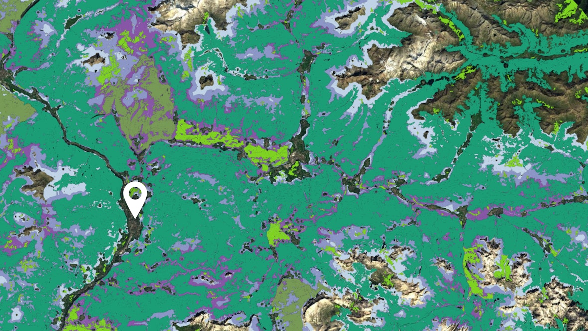
The ecological network of the red deer in the Puster/Pusteria valley (the white pin indicates the location of Brixen/Bressanone). The ecological network consists of key areas (aqua green), isolated habitats (olive green), intermediate connection areas (lime green), and ecological corridors (shades of purple), which together allow the animals to move between suitable habitats, reducing the effects of landscape fragmentation.Credit: Eurac Research
Professor Börger, Peter Laner has described an approach based on landscape characteristics. How do you study ecological connectivity?
Börger: My approach is based on animal-specific data collected in the field. For example, using radio collars. Thanks to these tools, we can track individual animals and their movements. We have also used sensors to measure the effort required by various animal species to move across slopes of varying steepness.
Are the two approaches alternative or complementary?
Börger: I’d say they’re complementary, because we can incorporate animal data into ecological connectivity models, such as the one for deer, to verify them and make them even more accurate.
Laner: I agree. To verify the accuracy of our ecological network model for deer, we also went out into the field. We wanted to understand whether the ecological corridors identified by the model were actually being used by the animals. We did this, for example, through snow tracking – searching for tracks in the snow. In some cases, the predictions proved to be very accurate; in others, we discovered the presence of barriers, such as fences, that the maps failed to capture. This is another reason why the data collected by ecologists is so valuable.
Börger: What Peter is saying is interesting because it shows just how important it is to compare models with reality. For a European project, we traveled thousands of kilometers to survey the barriers along river courses. We discovered that a great many structures were not listed in the official databases: in some countries, as many as 80% of the structures were missing. These included hydroelectric dams, water management structures, and infrastructure that was sometimes obsolete.

What are your hopes for the future?
Börger: I hope we’ll be able to develop increasingly realistic and predictive models capable of describing not only how animals move today but also how they’ll react to future changes in the landscape. That’s why I’m trying to bring together experts from around the world: I’d like everyone to contribute their data and experience to improve the models. The ultimate goal is to make this knowledge available to policymakers, planners, and engineers so they can examine the impact of new infrastructure or changes in land use – ahead of time. I would also like to see data from different species being integrated, because ecosystems are not made up of just one. The more the models are able to represent this complexity, the more useful they will be for making sound decisions.
Laner: South Tyrol is one of the last three regions in Italy without a provincial ecological network plan and it’s the last one in the Alps. The current landscape plan dates back to 2003, and at that time, ecological connectivity was not even a consideration. My hope is that the plan will finally be updated and that decision-makers will take our model into account.
It is essential to work both on a local scale and on a broader geographic one to ensure that the most important ecological corridors are identified, enhanced, and protected. That is why we developed an ecological connectivity model at the Alpine level, and then a specific one for red deer in South Tyrol: to develop an approach that harmonizes the networks of different regions, especially near borders. Finally, I hope there will be increasing dialogue between scientific researchers and policymakers, so that the knowledge we have generated translates into a tangible impact on the territory.









 My cookie preferences